Full Paper about “Solar Energy Estimation using Street-view Images” accepted at the Journal of Cleaner Production

Our paper entitled Towards feasibility of photovoltaic road for urban traffic-solar energy estimation using street view image has been accepted for publishing in the Journal of Cleaner Production.

Authorship: Ziyu Liu, Anqi Yang, Mengyao Gao, Hong Jiang, Yuhao Kang, Fan Zhang, Teng Fei.

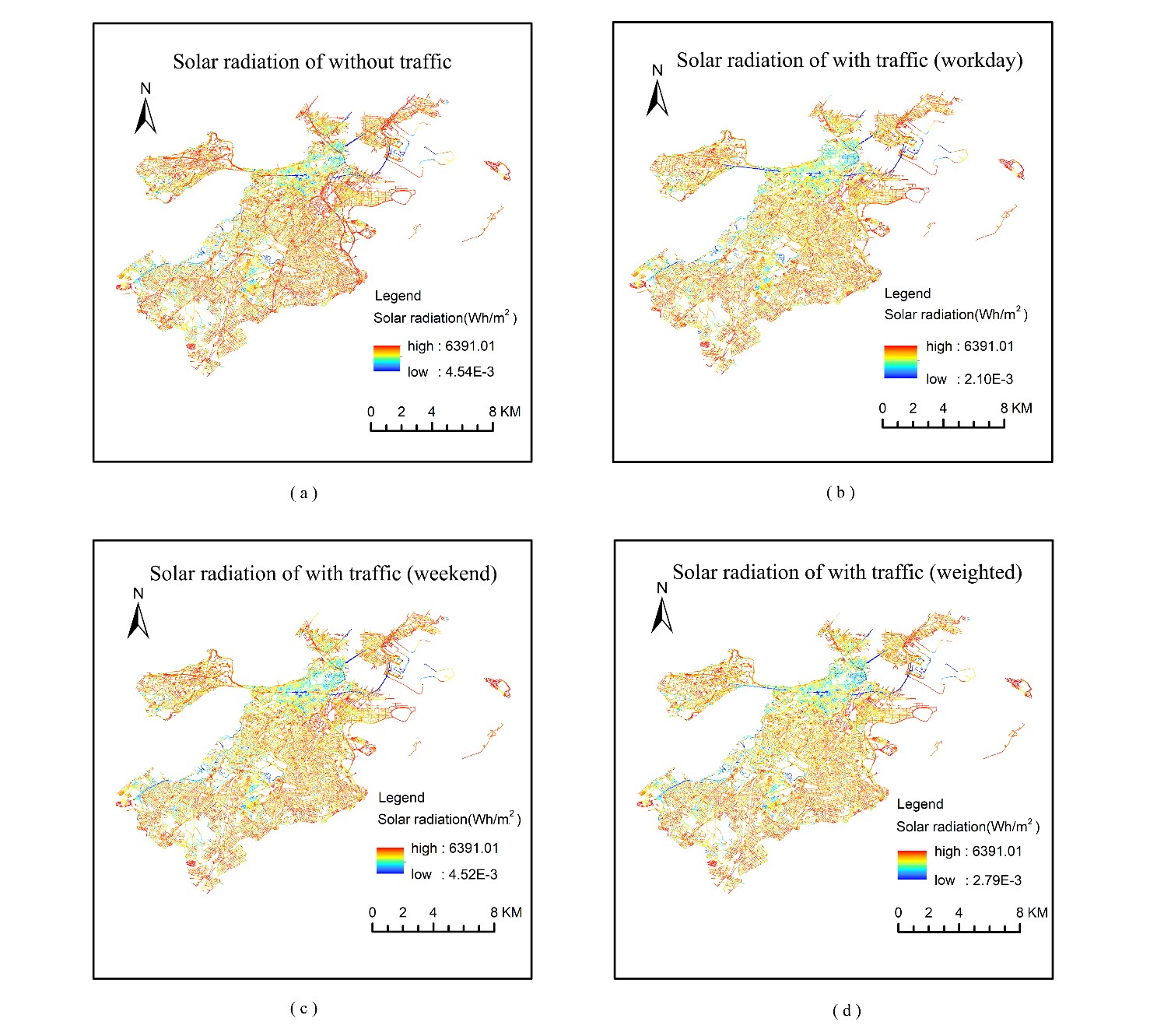
This paper proposes a methodology framework to calculate the solar energy that can be collected by solar panels paved on the road. Estimation of how much energy can be collected help making decision of where these photovoltaic road system should be built. Exemplified by the city of Boston, using street view images and taking light obstacles, traffic conditions, weather conditions and seasonal changes of solar radiation into consideration, the potential of solar energy generated by Boston’s road network is estimated precisely. Our results show that the energy obtained from urban road network can support all private cars in Boston.

Here is the abstract:
A sustainable city relies on renewable energy, which promotes the development of electric vehicles. To support electric vehicles, the concept of charging vehicles while driving has been put forward. Under such circumstances, constructing solar panels on urban roads is an innovative option with great benefits, and the accurate calculation of road photovoltaic power generation is a prerequisite. In this paper, we propose a novel framework for predicting and calculating the solar radiation and electric energy that can be collected from the roads. Google Street View images are collected to measure the sky obstruction of roads which is integrated with the solar radiation model to estimate the irradiation receiving capability. In addition to sky obstruction, we also take the impact of traffic conditions and weather situations into consideration in the calculation. Radiation maps at different times in a year are produced from our work to analyze the roads photovoltaic distribution. In order to test the feasibility of our framework, we take Boston as a case study. Results show that roads in Boston can generate abundant electricity for all future electric vehicles in the city. What’s more, main roads through Boston exhibit better power generation potential, and the effect of the traffic condition is limited. Our calculation framework confirms that utilizing solar panels as road surfaces is a great supplement of city power with the unique ability to charge moving cars.

Solar radiation along streets at Boston

Funded Project: Geo-mapping antimicrobial resistance in E. coli from humans & animals in Wisconsin

Recently, Dr. Laurel Legenza (PI) from the UW School of Pharmacy, Dr. Thomas R. Fritsche (Co-PI) from the Marshfield Medical Center and Professor Song Gao participating as a geospatial analysis scientist along with the State Cartographer’s Office (SCO) and other multidisciplinary collaborators, have been awarded a pilot grant from the UW Institute for Clinical and Translational Research (ICTR) and the Marshfield Clinic Research Institute for a research proposal titled “Geo-mapping antimicrobial resistance in E. coli from humans & animals” in Wisconsin.

The AMR Tracker tool, shown in the screenshot above, provides a map showing an array of antibiotics that might be prescribed to treat an infection (in this case, E.coli), and which one can be expected to work best in a specific geographic location. This could help doctors choose the right drug for their patients.

When a patient arrives at a hospital with an infection, his/her doctor must decide which antibiotic might have the best chance of curing him/her — no easy feat when disease-causing pathogens are increasingly resistant to multiple antibiotics. To make this data more accessible, a team of researchers at the University of Wisconsin–Madison School of Pharmacy and the State Cartographer’s Office have developed a prototype system that maps out trends in antibiotic resistance across the State of Wisconsin, which provides guidance at a glance of the likelihood a pathogen will respond to a particular drug.

More details: [Link]

Full Paper about “Human Emotions at Places” accepted at Transactions in GIS

Our full paper entitled Extracting human emotions at different places based on facial expressions and spatial clustering analysis” has been accepted for publishing in the journal of Transactions in GIS, which is also part of the special issue on GIScience Research Sessions for the 2019 Esri User Conference.

Authorship: Yuhao Kang, Qingyuan Jia, Song Gao, Xiaohuan Zeng, Yueyao Wang, Stephan Angsuesser, Yu Liu, Xinyue Ye, Teng Fei.

This paper proposes a methodology framework to measure human emotions at places with advanced artificial intelligence technologies and explore the relationship between human emotions and environmental factors. And a ranking list of tourist attractions around the world is created based on human happiness measured using over 2 million facial expressions.

Human happiness scores at world tourist attractions.

Related to this work, Yuhao Kang won the first place in the 2019 AAG Robert Raskin Student best paper competition. Link: http://gis.cas.sc.edu/cisg/?page_id=126

Here is the abstract: The emergence of big data enables us to evaluate the various human emotions at places from a statistic perspective by applying affective computing. In this study, a novel framework for extracting human emotions from large-scale georeferenced photos at different places is proposed. After the construction of places based on spatial clustering of user generated footprints collected in social media websites, online cognitive services are utilized to extract human emotions from facial expressions using state-of-the-art computer vision techniques. And two happiness metrics are defined for measuring the human emotions at different places. To validate the feasibility of the framework, we take 80 tourist attractions around the world as an example and a happiness ranking list of places is generated based on human emotions calculated over 2 million faces detected out from over 6 million photos. Different kinds of geographical contexts are taken into consideration to find out the relationship between human emotions and environmental factors. Results show that much of the emotional variation at different places can be explained by a few factors such as openness. The research may offer insights on integrating human emotions to enrich the understanding of sense of place in geography and in place-based GIS.

Tourist attraction ranking based on the average happiness index using facial expressions.

Prof. Michael F. Goodchild visited UW-Madison

Recently, Prof. Mike Goodchild was invited to visit our lab and the Department of Geography at the University of Wisconsin-Madison. Prof. Goodchild is the Emeritus Professor of Geography at the University of California, Santa Barbara. He was elected member of the National Academy of Sciences and the American Academy of Arts and Sciences, etc. He gave a talk titled “Geography and GIScience: An Evolving Relationship” in the department Yi-Fu Tuan Lecture series on Friday, April 19th, shared his view of how GIScience and Geography evolved together during the past decades.

The GeoDS lab also invited Prof. Goodchild to join our research group meeting. Four lab members presented their recent works and received insightful suggestions and comments from Prof. Goodchild.

Timothy Prestby Received the HILLDALE FELLOW Award

Please join us congratulating our junior student Timothy Prestby, who is currently an undergraduate research assistant in the GeoDS Lab under Prof. Song Gao’s mentorship, just got the university “Hilldale Undergraduate/Faculty Research Fellowships” and was awarded  in the 2019 Chancellor’s Undergraduate Awards Ceremony! 

The awarded research project title is: Understanding Neighborhood Isolation through Big-Data Human Mobility Analytics”. 

Previous Hilldale Fellows at the University of Wisconsin-Madison:

https://awards.advising.wisc.edu/campus-wide-award-recipients/test-hilldale-fellows/

GeoDS Lab at the 2019 AAG Annual Meeting

During the last week (April 3-7), six GeoDS lab members have actively participated in the 2019 AAG Annual meeting and successfully presented their work. Especially congratulations to Yuhao Kang who won the first place in the Robert Raskin Student best paper competition!

Yuhao Kang presented his work titled “Human Emotions at Different Places: A Ranking of Happiest Tourist Attractions around the World Based on Facial Expressions and Spatial Clustering Analysis” in the Cyberinfrastructure Specialty Group Student paper competition Session. [Abstract]. Robert Raskin Student Competition 2019: http://gis.cas.sc.edu/cisg/?page_id=126

Yunlei Liang presented her work titled “Optimizing Bus Stop Spacing Using a Spatial Interaction Coverage Model and the Maximal Covering Location Problem Model” in the Spatial Analysis and Modeling Specialty Group Student paper competition Session. [Abstract]

Mingxiao Li presented his work titled “Reconstruction of human movement trajectories from large-scale low-frequency mobile phone data” in the GeoAI and Deep Learning Symposium. [Abstract]

Yuqi Gao presented her work named “Analyzing Regional Economic Indicators from Transportation Network Analytics” in the Automated GISci for Network-based Decisions Session. [Abstract]

Timothy Prestby presented his work titled “Linking Traffic Volume to Economic Development Index Using Big Data and Gravity Models” in the Urban Geography Poster Session. [Poster]

Professor Song Gao co-organized The 2nd AAG Symposium on GeoAI and Deep Learning for Geospatial Research and was invited to the panel discussions of “Urban Data Science”.

Congrats to all of them! Go Badgers!

Group Photo